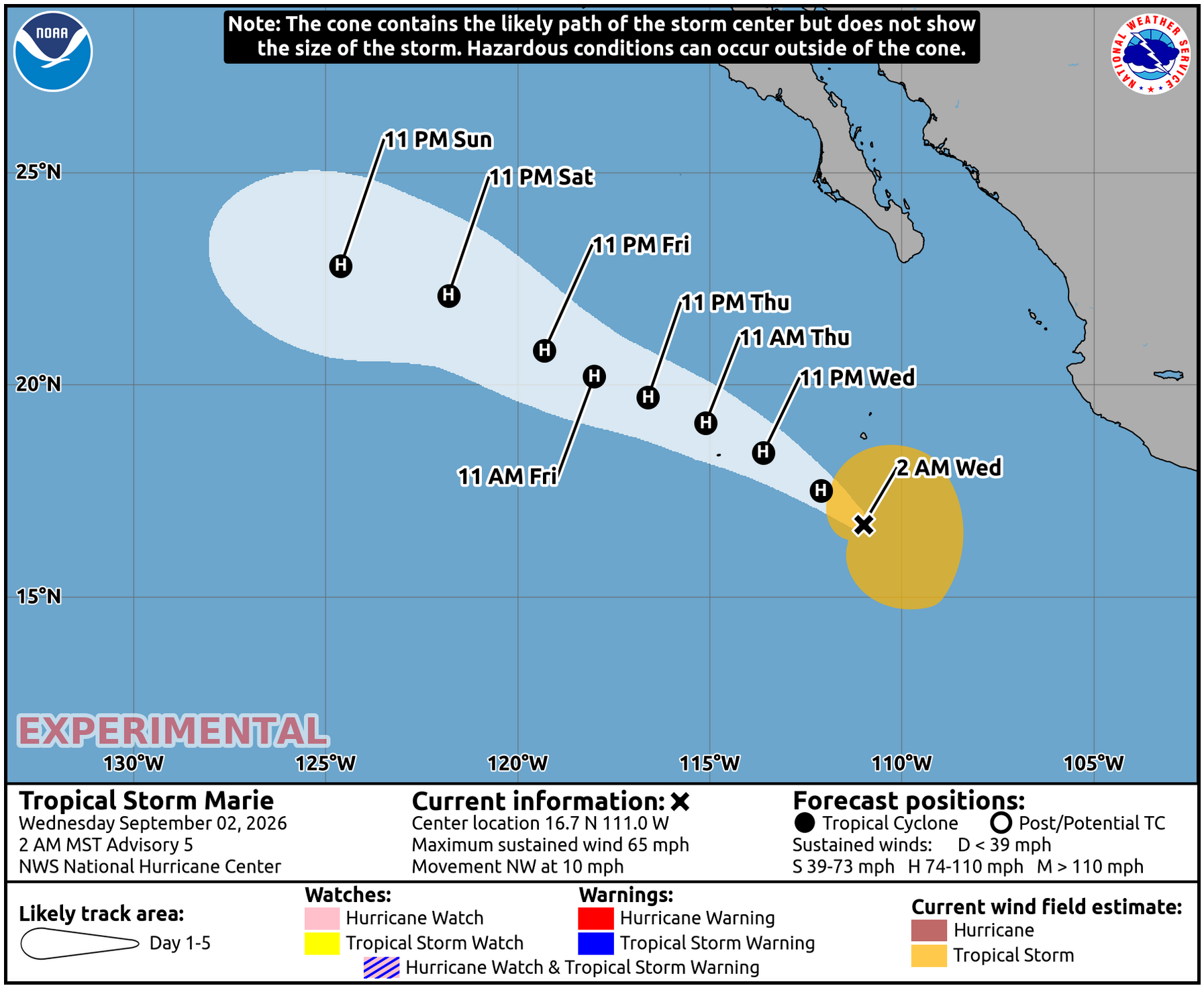
Tropical Storm Marie is expected to strengthen into a hurricane by Wednesday night, raising the threat of dangerous surf and coastal flooding along Encinitas beaches over Labor Day weekend.
As we reported Sept. 1, the storm was already on forecasters' radar. The National Hurricane Center now projects Marie will reach hurricane strength before weakening again late Saturday, according to NBC 7 San Diego. By Sunday, the storm is expected to be about 775 miles southwest of San Diego.
Marie is not expected to make landfall in Southern California.
No coastal watches or warnings were in effect as of Tuesday, Sept. 1. "By the time this storm reaches Southern California, it will very likely be below hurricane status and even tropical storm status," Sebastian Westerink, a meteorologist with the National Weather Service's San Diego office, told the Los Angeles Times.
The storm doesn't need to arrive intact to cause problems on the coast. Tropical swells are forecast to reach San Diego County by Saturday or Sunday, coinciding with high tides of 6.2 to 6.5 feet, the NWS said. South-facing beaches like Swami's and Cardiff Reef sit directly in the path of a south swell.
Kristan Lund, a meteorologist with the NWS office in Oxnard, told the Los Angeles Times there is increasing confidence in moderate-to-large surf starting as early as Friday, with above-normal tides raising the risk of coastal flooding along south-facing shores.
Kevin Wallis, a Surfline forecaster, told the San Diego Union-Tribune on Monday, Aug. 31, that Marie "could be the largest tropical swell of this active season." He described the storm as being on a favorable track for Southern California swell production.
Ocean temperatures are fueling the storm's strength. Sea-surface temperatures exceeded 80 degrees during the week of Aug. 24 at a buoy off northern San Diego County, at least eight degrees above normal, according to Jay Cordeira, an atmospheric scientist at UC San Diego's Scripps Institution of Oceanography, as reported by the Union-Tribune.
The NWS also said the storm could bring showers and a slight chance of thunderstorms from Saturday into Monday, Sept. 7. Most forecast models indicate light precipitation, with skies likely clearing by Tuesday of next week.
As of Tuesday, Marie was about 1,300 miles south-southeast of San Diego with maximum sustained winds of 45 mph, moving northwest at 9 mph. It is the 13th named storm of the 2026 Eastern Pacific season.
The San Diego County Office of Emergency Services has previously warned that Pacific hurricanes do not need to make landfall to affect the county. The NWS said it will update its forecast as Marie's track sharpens ahead of the Saturday-through-Monday holiday weekend.